THE VICTORIA FALLS
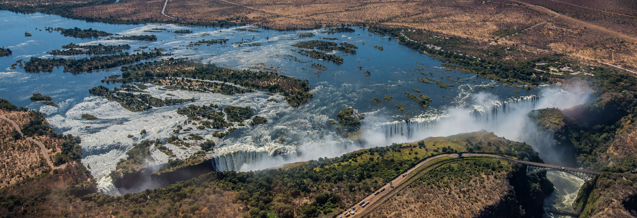
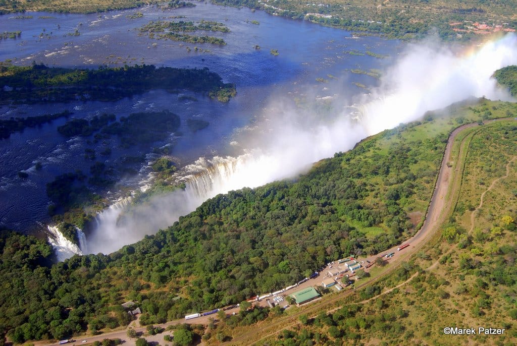
The Victoria Falls presents a spectacular sight of awe-inspiring beauty and grandeur on the Zambezi River, forming a natural border between Zambia and Zimbabwe. It was described by the Kololo tribe living in the area as ‘Mosi-oa-Tunya’ – ‘The Smoke that Thunders’ for the immense spray and incredible noise caused by the rushing water. Victoria Falls is now also known as the greatest curtain of falling water in the world when its width and height are combined.
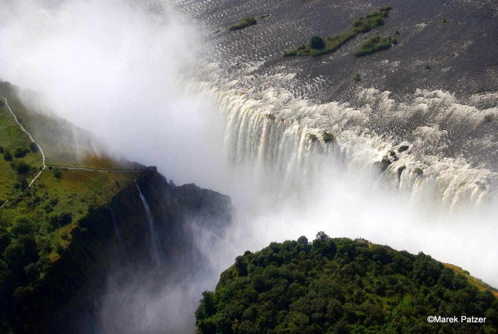
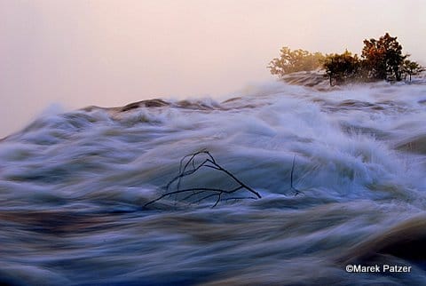
Columns of spray can be seen from miles away as, at the height of the rainy season, more than five hundred million cubic metres (over 17 billion cubic feet) of water per minute plummet over the edge, over a width of nearly two kilometres or over a mile, into a gorge over a hundred metres or 300 feet below.
The wide basalt cliff over which the Falls thunder transforms the Zambezi from a placid river into a ferocious torrent cutting through a series of dramatic gorges.
Facing the Falls is another sheer wall of basalt, rising to the same height, and capped by mist-soaked rain forest. A path along the edge of the forest provides those prepared to brave the tremendous spray with an unparalleled series of views of the Falls.
One special vantage point is across the Knife-edge Bridge, where you can have the finest view of the Eastern Cataract and the Main Falls as well as the Boiling Pot, where the river turns and heads down the Batoka Gorge. Other vantage points include Livingstone Island, the Falls Bridge, Devil’s Pool and the Lookout Tree, both of which command panoramic views across the Main Falls.
MORE INFORMATION
- Width: 1 688m / 5 538ft
- Height: 108m / 354ft
- Flow rate: 1 088m³ / 3 570m³
- Known as: The Smoke that Thunders
- Named after: Queen Victoria of Great Britain
- National Park: Mosi-oa-Tunya
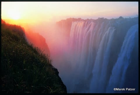
Different times of the year provide completely different experiences of the Falls. Peak flood season is around March and April when the full power of the Falls can be experienced in all its glory. Due to the masses of spray rising from the fallen water, the full width of the Falls cannot be seen on foot (and raincoats or umbrellas may be necessary). The aerial view (from microlights, helicopters or planes) at this time is spectacular, with clouds of spray rising high into the sky.
As the flood abates, the actual view of the Falls gets better and better through the year until about September. From October, as the dry season reaches its peak, parts of the Falls dry up. At its lowest, around November and December, it becomes little rivulets running over the edge and in some places, no water falls at all. The delight of visiting the Falls in this season is the view of the impressive cliffs that form the basalt wall, and the magnitude of the abyss can be fully appreciated. There are trips by raft to the base of the Falls in low season called ‘the float of angels’.
The Falls can be approached from the town of Livingstone by travelling south on Mosi-oa-Tunya Road for about 11km / 6.8mi . Just before the border, there is a turning to the right that leads to a parking area. Walks all around the Falls are accessible from this point. If approaching from Zimbabwe, cross the border at the town of Victoria Falls and watch for the left turning just after the Zambian customs post.
In 1851, Dr David Livingstone first heard of the great waterfall but it was only in 1855 that he set out to visit it. He spent the night on Kalai Island upstream of the Falls, having come down river by foot, and the next morning set off in a small canoe to approach the thundering ‘smoke’. He landed on the biggest island on the lip of the Falls – now called Livingstone Island – and from there obtained his first view of the Falls.
‘Creeping with awe to the verge, I peered down into a large rent which had been made from bank to bank of the broad Zambezi, and saw that a stream of a thousand yards broad leaped down a hundred feet and then became suddenly compressed into a space of fifteen to twenty yards… the most wonderful sight I had witnessed in Africa.’
Of the surrounding area he wrote in 1857, ‘No one can imagine the beauty of the view from anything witnessed in England. It had never been seen before by European eyes, but scenes so lovely must have been gazed upon by angels in their flight’.
It is thought that earth movement in an earlier geological period diverted the south-easterly flowing upper Zambezi River to a general easterly direction and so initiated the development of a waterfall in an area occupied by a massive bed of basalt that is about 305m / 1 000ft thick.
The basalt, through which the Zambezi runs for 209km / 130mi in the Livingstone area, is characterised by very marked joints or cracks, which may have developed as the molten lava cooled. One dominant series of joints running in an east-west direction is associated with zones of soft material within the basalt.
Since the Zambezi is flowing due south in the Livingstone area, these softer materials are very easily eroded to form the great east-west gorges. Upstream retreat of the Falls is due to a second major series of joints running north-south. Gradual erosion of small joints that run north-south caused the river to be concentrated into a narrow fissure and the broad fall line was abandoned. Once this happened, it was only a question of time before the narrow gorges cut back into another transverse fracture zone of soft material. This gouging out of the soft zone again established a broad fall. This process has been repeated over many years and the zigzag gorges represent seven previous lines of waterfalls.
The Devil’s Cataract, on the Zimbabwe side, which is lower than the rest of the present Falls, shows how the force of water is starting to cut back along such a line of weakness. It will probably erode its way back to another east-west joint where a future line of the waterfall will eventually become established.
VICTORIA FALLS ACTIVITIES
If action, adventure and a surge of adrenalin are your thing, then why not experience it all while visiting the adventure capital of Southern Africa?
The wide basalt cliff of the Falls transforms the placid Zambezi River into a furious torrent, cutting through a series of dramatic gorges. This allows for a multitude of adventures from aerial and death-defying, or up-close-and-personal.
Peak flood season is around March and April when the full power of the Falls can be experienced in all its glory.
FEATURED LISTINGS
Tafika Camp- Remote Africa Safaris
Type: Bush Camp
Area: South Luangwa
Rate from: $795
Tongabezi Lodge
Type: Lodge
Area: Livingstone
Rate from: $495